 |
A book by William H. Calvin UNIVERSITY OF WASHINGTON SEATTLE, WASHINGTON 98195-1800 USA |
|
How the Shaman Stole the Moon Copyright ©1991 by William H. Calvin. You may download this for personal reading but may not redistribute or archive without permission (exception: teachers should feel free to print out a chapter and photocopy it for students). |
|
Half a View Provides the Clue
Hiking down to "paradise," it was difficult to maintain my preoccupation with why solstice sightlines were so common; the views are too distracting. I have no idea what the Anasazi’s name for Canyon de Chelly was, but I’ll bet that it was something like "paradise." About 30 stories deep, the canyon’s cliff-like walls are forbidding in most places. Unlike Chaco’s half-mile-wide bottom, the flat bottomlands of Canyon de Chelly are only about a block or two wide. A creek flows along peacefully, and it is good farm country. This is a protected place, just the sort that novelists create, with hidden entrances that open from a desert into a garden paradise. Small wonder that the Navajo treasure it. Surely the Anasazi did. Canyon de Chelly is west of Chaco, just over the Arizona border. Like Betatakin, it is now a national monument surrounded by the Navajo Indian Reservation. The Navajo are not Pueblo peoples, but they seem similar in many ways. Their agriculture, even their religion, has many elements in common with the Pueblos. The Navajo are even closer to hunting and gathering than the Pueblo peoples, having hunted and gathered their way down to the Southwest from the far north a mere 500 years ago. They, and the Apache to their south and the Utes in Colorado, are Athapaskan peoples, the linguists first having discovered these relationships from the similarity of their languages to those of the Indians of Alaska and Canada’s Yukon Territory. Had Columbus discovered the New World a few centuries earlier, the conquistadors wouldn’t have seen any "Apaches with cultivated fields" (that’s said to be how the Navajo got their Spanish name). The Navajo learned farming from the Pueblo peoples, and settled down to compete with them for territory. They are now far more numerous: 210,000 Navajo versus 50,000 Pueblo peoples. The Navajo even adopted many elements of the Pueblo religion which, once one understands how intertwined are the Pueblo agricultural practices with their religious customs, makes some sense. The Navajo have been a vigorous, adaptable people - but because of that, their hunter-gatherer Athapaskan culture has been waning. This is what usually happens, and what makes the really conservative Pueblo peoples so important. Perhaps their close identification with their traditional surroundings makes them slow to adopt new ways or move to new places. The Pueblos may not be particularly representative of Anasazi-style ancestors - not any more than such highly-conservative sects as the Amish are representative of European postindustrial civilization. Still, a composite guess about any neolithic American culture is infinitely better than what we know of the Stone Age people who built Stonehenge, which, outside of megaliths, toolmaking technology, and some population density estimates, is almost nothing. |
THIS "PARADISE" IS SHAPED like a wishbone. Canyon de Chelly has two arms, each extending about 20 miles; one runs northeast and the other southeast from their junction. Anasazi cliff-dwellings there are set back into great alcoves like those of Anasazi Valley and Betatakin. White House Ruin is in the southeast branch. The hiking trail to it passes some unusual shapes eroded into the sandstone. One looks like a pair of eyeglasses, hollow sockets behind them. Smaller hollows have trapped blowing soil over the years, and then some seeds, and now bright green plants hang here and there along the reddish-brown cliffs. Down and down the trail winds. Eventually one comes to a tunnel hewn out of the rock in recent decades, saving the visitor a somewhat perilous traverse along a cliff ledge that the Indians probably didn’t mind very much. Emerging from the tunnel, you are amidst trees, and an unusual farmhouse lies ahead. It is a traditional Navajo hogan, a round one-room house, with a doorway facing east. I think that some novelist I’ve read must have been there before me - I had a strong sense of déjà vu as I came out of the tunnel into the sunny bottomlands. The path continues through some sheltering cottonwood trees, and then opens out onto the banks of the wide creek. Except where the creek narrows down, the water seems to be less than knee-deep. As you look up, the opposite canyon wall rises, and you see a large alcove containing many cliff-dwellings. Large streaks of black desert varnish lead down from the top of the cliff like paint-can drips, terminating all around the alcove, a magnificent sight. Close up (and slightly wet), you see a series of rooms on the bottomland of the canyon, rooms that probably were flooded during a spring runoff. A few stories above them, requiring a ladder to reach, is the ground floor of the alcove, facing south as a proper Anasazi alcove should. The Anasazi used ladders made out of thin tree trunks, cutting off branches in such a way as to leave enough for a step. The Park Service has prepared the lower rooms for the onslaught of visitors, but the upper stories are plainly intended to be permanently out of reach to non-Anasazi. The alcove seems a likely candidate for solstice corners, from somewhere in its depths, worth investigating with pocket transit - however, that’s for another day. The cottonwoods near the creek afforded shade in the summer; the alcove got the low winter sun much of the day. By Anasazi standards, there was a lot of water; they were likely the envy of their neighbors, which may explain why the access to the cliff-dwellings was not improved by cutting steps into the cliff face. When outlying marginal areas dried up and lost their corn crop, which happened every few decades in this land of fickle rainfall, those outlying people probably searched for a source of grain. Canyon de Chelly surely had water when most others didn’t, and they were probably raided for food supplies. That’s one disadvantage of living in paradise. You can see high ledges near the top of some alcoves, big enough for birds to roost. But the birds’ space seems to have been usurped by a few sealed pots of grain. They’re hard to get to, probably requiring little-known steps and ladders hidden down the canyon somewhere, so most raiders never managed to get up there before being driven off. The hidden grain could serve as the backup supply for the inhabitants of paradise - and, even more importantly, serve as the essential seed corn, sure to be available at planting time next spring, no matter how hungry people got. Its inaccessibility was probably intended to keep out the local people in times of hunger, as well as any starving raiders. |

|
I SETTLED DOWN IN THE SHADE of the cottonwoods on the south side of the stream, with a
view of the White House alcove across the way, complete with the long desert-varnish "drips"
overhanging it. And I tried to work out the accumulated puzzles. Anasazi astronomy seems, at first glimpse, to be a more detailed version of those archaeoastronomy findings from around the world: judging by how stones are aligned and where buildings are constructed, solstice directions were very popular. Yet agriculturally, nothing interesting happens in midwinter or midsummer. And even if it did, the sunrise position changes so slowly at the solstices that you’d get year-to-year fluctuations of a week or more (in the Pekwin story, 20 days!). Those Hopi conventions about intermediate sunrise positions for planting time are simplicity itself. A different kind of usefulness, as Columbus made clear, is eclipse prediction. It can be a powerful technique for personal advancement (or saving one’s neck); perhaps that is what’s behind constructing solstice sightlines, not agricultural considerations? Yet none of the simple entry-level methods (nor, I might add, any of the known intermediate-level methods such as the 56-hole Stonehenge ones and the Mayan cycle) use solstices explicitly; the counting-by-sixes prediction doesn’t even use sightlines at all. What’s so handy about solstice sightlines to the eastern and western horizons? Surely there is a way to match up the usefulness of eclipse forecasting to the most common astronomical interest expressed by many prehistoric peoples. |
|
MY LUNAR ECLIPSE WARNING METHODS seem to require a reasonably horizontal western
horizon and a reasonably horizontal eastern horizon. Opposite Views, as it were. If you live on
an island, you hike to the south end or the north end, and you will have a sea horizon in both
directions, just as at the Temple of Poseidon. On a large continent such as North America,
however, finding the proper horizon can take some effort - such as hiking to the tip of the Florida
peninsula, or the Yucatan peninsula, or Baja California. Puget Sound, with all its islands and peninsulas combined with long stretches of water, is potentially an exception - but I still had trouble finding a viewpoint with long stretches of water to northwest and southeast plus low horizons, from which to observe an lunar eclipse in early August. I only located one such spot on the map, Dungeness Spit in the Strait of Juan de Fuca, which required a ten mile round-trip hike to get far enough out to clear the horizon obstructions. I found a second spot on Whidbey Island, to the north of Seattle, with a five mile path over water, but its southeast horizon was a little too high. One could, I suppose, try the higher mountaintops, which, while lacking in shining streaks of water (and requiring camping there overnight), are otherwise acceptable for distant horizons. I kept thinking wistfully of the high mesas in Anasazi country, with their long views, or the plains of Kansas where opposite views are easy to find. Most people live in places without easy access to nice views of the sort I’ve been thinking in terms of, with their opposite views. Alas. If only there were some eclipse-warning use of half a view, some way to use northeast-to-southeast sunrise views without any need for a view to the sunset. How does one adapt to half a horizon? |
|
THEN I REMEMBERED what Fred Hoyle had mentioned in passing in his Stonehenge book:
when a lunar eclipse is due, the sun rises that morning about as far north of due east as the full
moon will rise that evening to the south of due east (or vice versa). The simple rule is: Equal
angles from due east.
But how did they know where due east is located? Determining the equinox is possible using Two Priests, but it still seems a bit of a leap, given that the Anasazi’s favorite directions emphasized the solstices rather than our north-east-south-west cardinal directions at 0°-90°-180°-270°. So a method using due east is surely not a primary discovery but rather something intermediate, after the virtues of a right-angle coordinate system were discovered. Then I tried Hoyle’s method, but used the Pueblo’s 60°-120° solstice sunrise directions instead of due east at 90°. Suppose, for example, that they measured the 70° sunrise in mid-May as just 10° from the nearest solstice direction, i.e., the one at 60°. The sun would set 10° south of the 300° solstice direction at 290°, which would make its conical shadow 10° north of the winter solstice sunrise line at 120°. And indeed 110° is the eclipse-prone position of moonrise. Hoyle’s method works with the Anasazi’s coordinate system as well as ours! The simple rule is: If moonrise tonight is as far from the nearest solstice sightline as sunrise this morning was from the other solstice, watch out for an eclipse. |
 Hoyle’s method is really a variation on the 180° methods, and depends on the
sunrise and sunset being equally far from the east-west line each day. If the sun rises 20°
north of due east, i.e., at 70° from north, then it will set about 20° north of due west
that evening (290°; within 0.5°, at least). That means that the conical shadow will
rise 20° south of due east, right? At 110° from north? So that’s the eclipse-prone position for a moonrise.
Hoyle’s method is really a variation on the 180° methods, and depends on the
sunrise and sunset being equally far from the east-west line each day. If the sun rises 20°
north of due east, i.e., at 70° from north, then it will set about 20° north of due west
that evening (290°; within 0.5°, at least). That means that the conical shadow will
rise 20° south of due east, right? At 110° from north? So that’s the eclipse-prone position for a moonrise.|
COMPARING TWO ARCS, however, seems very different from the other methods; this eastern-horizon-only method isn’t entry-level, something that a prehistoric priest might have
stumbled into. It is more complicated because you have to compare the sunrise’s
"distance" from a solstice sightline - a difference in sightlines, if you like - to what you see that
evening at moonrise, discern if the full moon is the same "distance" from the other easterly
solstice sightline. Such a method isn’t really like measurement with a ruler, where you
count your way along a graded scale; instead, it involves rendering a same-or-different judgment.
We’ve solved the lunar eclipse warning problem for those folk living on a eastern coastline, having a sea horizon but only to the east. What about those poor folks inland, with an even horizon that is, alas, elevated several degrees? It will still work, surprisingly enough: those terrible problems with the 180° methods when horizons are elevated (changing a straight line into a dogleg) are minor when dealing with only an eastern horizon. Both sunrise and moonrise are shifted south, but by nearly equal amounts: since you’re always comparing sunrise and moonrise directions with the solstice directions (also shifted), the errors cancel if the horizon between solstice sightlines remains equally elevated. |
 I doubt that the Anasazi needed any abstract notion of arcs and angles (the way that we teach
geometry) in order to use this half-a-horizon method. Because the Anasazi were so fond of
beaded necklaces, I imagine them holding the necklace at arm’s length in the morning,
with one end at the solstice sightline, finding the bead that was under the sunrise and then sliding
the remaining beads away from this "sunrise bead," perhaps tying a knot there. And then that
same evening, they would hold up the necklace to the moonrise and see if the full moon came
close to the sunrise bead when the necklace’s end was aligned with the other solstice
sightline. Call it Method #7 ("The Arm’s-Length Necklace").
I doubt that the Anasazi needed any abstract notion of arcs and angles (the way that we teach
geometry) in order to use this half-a-horizon method. Because the Anasazi were so fond of
beaded necklaces, I imagine them holding the necklace at arm’s length in the morning,
with one end at the solstice sightline, finding the bead that was under the sunrise and then sliding
the remaining beads away from this "sunrise bead," perhaps tying a knot there. And then that
same evening, they would hold up the necklace to the moonrise and see if the full moon came
close to the sunrise bead when the necklace’s end was aligned with the other solstice
sightline. Call it Method #7 ("The Arm’s-Length Necklace").|
EUREKA might now seem an appropriate exclamation. Solstice directions are very useful
because their sightlines serve as reference directions, allowing the use of the lunar eclipse
warning methods on a northeast-to-southeast horizon, without any requirement about
what’s seen in the west. Exhibit B, explained? And that may solve, in the same stroke, the puzzle of the elevated banks at the British megalithic monuments, what I called Exhibit A. The mildly elevated horizon isn’t a complication any more - just as long as it is uniformly elevated above a true horizontal (at least, in that one-sixth of the circle that you need, bracketing due east). You can take a bumpy horizon and flatten it out, just by building a level bank to obscure the bumps, across which you view sunrise and moonrise. They’ll be shifted south a little, but so what? You establish the solstice directions in the presence of the elevated bank. Then you use those solstice sightlines at the full moon each month, to compare moonrise and sunrise positions. |
 I WAS HAPPILY playing in the sand alongside the creek when some hikers walked by. They
probably thought that I was a little old to be building sand castles - and certainly out of practice.
After all, the moat is the last thing that one builds, after the central structures. But I was building
only an elevated bank, with no castle. The easy construction technique for a bank is to dig a
ditch and pile the sand along one side of it. The water table being what it is in the creek bed, my
ditch slowly filled up with water. But what’s important for eclipse forecasting is that
elevated bank.
I WAS HAPPILY playing in the sand alongside the creek when some hikers walked by. They
probably thought that I was a little old to be building sand castles - and certainly out of practice.
After all, the moat is the last thing that one builds, after the central structures. But I was building
only an elevated bank, with no castle. The easy construction technique for a bank is to dig a
ditch and pile the sand along one side of it. The water table being what it is in the creek bed, my
ditch slowly filled up with water. But what’s important for eclipse forecasting is that
elevated bank.But the moat is not merely a byproduct: it is very useful, as it provides an easy way to level the top of the bank. The water is horizontal, so long as no one is making waves. Just take a stick with a side branch remaining, and smooth the sand atop the bank while keeping the bottom of the stick at exactly the water line. That way, the top of the bank will be almost as level as the water’s surface. For an observer near the center of the circle, it’s a uniformly elevated horizon. At Avebury and Stonehenge, the winter rains probably filled the ditches that they dug into the underlying chalk. And all that floating chalk debris probably left behind one of the world’s more obvious bathtub rings, allowing year-around construction to reference the high water line. A tree trunk with a side branch could be used to scale up my sand castle technique to flatten the top of the bank. Pivoting around a corner-producing post or tower also ought to work well with an elevated bank. The pivot could be outside the bank, something like the Heel Stone at Stonehenge. Or the pivot could be inside the circular bank, though the accuracy would suffer unless you had a very big circle. So long as the pivot stuck up above the bank, as seen from the observer’s path inside, you could track sunrise and moonrise, and compare them via the distances along the arc. At the south end of the observer’s arc is the position for seeing summer solstice sunrise aligned on the pivot. At the north end, the winter solstice sunrise would look exactly the same, in the corner of the post or tower. To measure the two arcs - no, it is comparing, not measuring - to compare the moonrise’s distance from the nearest solstice with what sunrise did that morning, I’d suggest using extra-long necklaces, the kind that can be looped around your neck a dozen times. Stretch the necklace out from the sunrise viewing position to the nearest solstice sightline, then pick it up and carry it over to the other solstice, stretch it out to predict the moonrise position.
|
 A long stick would also suffice, held with one end against a post at the nearer solstice sightline:
just walk over to touch the stick to the other solstice post while holding the stick in the same
place, and you will be at the observation position at which an about-to-be-eclipsed full moon will
rise tonight in the pivot corner. The size of the stick, or length of the necklace, depends on the
distance from pivot to observer’s path: the longer it is, the more accurate you’ll be.
Call it Method #8 ("The Stick").
A long stick would also suffice, held with one end against a post at the nearer solstice sightline:
just walk over to touch the stick to the other solstice post while holding the stick in the same
place, and you will be at the observation position at which an about-to-be-eclipsed full moon will
rise tonight in the pivot corner. The size of the stick, or length of the necklace, depends on the
distance from pivot to observer’s path: the longer it is, the more accurate you’ll be.
Call it Method #8 ("The Stick").| A UNIFORMLY-ELEVATED HORIZON is what allows those eclipse prediction methods to function in almost any locale - though canyons might be an exception if you’re fussy about success rate. Sites with 15°-high features on the horizon are not so promising, but I can imagine the 3° horizons at many locations in Chaco’s central valley as eligible for smoothing with a bank like Avebury’s or Stonehenge’s. I haven’t seen any such banks around there, however, and filling the adjacent ditches with water might have been harder in the desert than in England. Perhaps, I mused, there is another way to elevate the horizon and level it. |
|
HOW LONG does the level bank need to be? I’d sure want to make it as short as
possible, if I were doing the digging. The closer the horizontal edge is to the vertical pivot that
completes the corner, the less lengthy the bank can be. If the Heel Stone were the pivot at
Stonehenge, and they had put that bank just inside it, the bank would only have needed to be a
few paces long.
Simplicity - no bank and ditch are needed, merely a pivot point that is shaped such that you can hide the sun behind it. Your observation path could be a circular arc around the pivot point (actually, a straight line running north-south will work almost as well). Remember that you aren’t measuring per se, just comparing one arc with another (in post-Euclidian terms, you compare chords rather than arcs). Method #9 ("Pivot About the Frame") is a very forgiving method. |
 In fact, why not just make the artificial horizon at the pivot, as in those Framing the Sun
examples where the horizontal aspect stayed constant: use Framing the Sun, but also frame the
moon and compare the observer distances from the nearest solstice sightline! Just have the
observer maneuver until the rising sun (or moon) is sitting atop the horizontal but with one side
against a vertical. Or, if the sun is too high in the sky to look at, the observer obscures the sun
behind the pivot so that a slight gleam is seen at the top and another at the side. So long as the
observer’s path is level (and many an old lake bed is quite flat), the edge of a cliff top will
suffice as a frame (as long as it is higher than all the other horizon features that the observer sees
while walking along his semi-annual path).
In fact, why not just make the artificial horizon at the pivot, as in those Framing the Sun
examples where the horizontal aspect stayed constant: use Framing the Sun, but also frame the
moon and compare the observer distances from the nearest solstice sightline! Just have the
observer maneuver until the rising sun (or moon) is sitting atop the horizontal but with one side
against a vertical. Or, if the sun is too high in the sky to look at, the observer obscures the sun
behind the pivot so that a slight gleam is seen at the top and another at the side. So long as the
observer’s path is level (and many an old lake bed is quite flat), the edge of a cliff top will
suffice as a frame (as long as it is higher than all the other horizon features that the observer sees
while walking along his semi-annual path).|
THANKS TO THE PREOCCUPATION of New World archaeoastronomers with windows, and
the Old World archaeoastronomers with pivots, I realized that there is a homely substitute for
bank-and-ditch. The Navajo hogan just upstream from the cliff-dwellings reminded me of it,
what with its east-facing doorway. A level floor can, in effect, substitute for a level horizon, so
long as there is an east-facing window or door. I don’t have much experience living in hogans, so I’ll explain this method using my bedroom back in Seattle. My bed faces east, and there is a small window high on the eastern wall. In the summer, when the sun rises in the northeast, its first rays come in through the window obliquely and strike the southwest corner of the room. There’s a nice rose-colored patch of light, the shape of the eastern window. A half hour later, the shadow line of the window frame has moved down the western wall towards my bed, swinging both to the north and downwards as the sun swings south and up (the window frame acts as a pivot).
The same thing will happen in most Navajo hogans. The shadowline of the upper south corner of the east-wall door frame will sweep down the back wall of the hogan until it finally reaches the floor. Personally, were I trying to use a doorway, I’d create a little window atop the lintel by omitting some mud mortar - something like that hole drilled above the doorway in the square cave at Tsankawi - and use that little spot of light against the back wall rather than the door frame’s shadow. The hogan, being round, makes the method analogous to those circular pivot paths. But you could also do it with a west wall that ran north-south (you’re only comparing, not measuring), such as in my Seattle bedroom.
Method #10 ("The Hogan") is only as accurate as the room is large. Those great kivas at Chaco would have allowed far more accuracy than the typical kiva or hogan or Seattle bedroom (though there are some limits, from smearing out the shadow edges). When the method is used in a small room, it might be so inaccurate as to be worthless for eclipse prediction. Still, like the small sundials, it might have proven popular nonetheless - and, come to think of it, the great kivas are dated earlier than the small ones. |
 Suppose that on the summer solstice, we mark the floor, denoting where the shadow corner
intersects the floor. We do the same at winter solstice. Then on various mornings throughout the
year, we can lay out a necklace (or belt, or stick) along the floor from sunrise to nearest solstice,
and move it over to the other solstice mark in order to predict the eclipse-prone position of the
full moon that same evening.
Suppose that on the summer solstice, we mark the floor, denoting where the shadow corner
intersects the floor. We do the same at winter solstice. Then on various mornings throughout the
year, we can lay out a necklace (or belt, or stick) along the floor from sunrise to nearest solstice,
and move it over to the other solstice mark in order to predict the eclipse-prone position of the
full moon that same evening. The Pueblo people are known to use crystals inside kivas to reflect the light that shines through
the entryway; placing a crystal at the eclipse-prone position along the arc might serve to reflect
moonlight around the kiva, creating an eclipse warning visible to all. Several crystals either side
of the dangerous position (a rhinestone belt comes to mind) would help accurately measure the
umbra-penumbra boundary; the first crystal to glow as the shadow edge descends would serve to
mark the spot. Though star-watching has been mentioned to the Pueblo historians, I don’t
know of any evidence for seasonal sun-watching from within kivas in the historic Pueblos.
Traditional Pueblo secrecy, of course, makes the aphorism "Absence of evidence is not evidence
of absence" particularly cautionary.
The Pueblo people are known to use crystals inside kivas to reflect the light that shines through
the entryway; placing a crystal at the eclipse-prone position along the arc might serve to reflect
moonlight around the kiva, creating an eclipse warning visible to all. Several crystals either side
of the dangerous position (a rhinestone belt comes to mind) would help accurately measure the
umbra-penumbra boundary; the first crystal to glow as the shadow edge descends would serve to
mark the spot. Though star-watching has been mentioned to the Pueblo historians, I don’t
know of any evidence for seasonal sun-watching from within kivas in the historic Pueblos.
Traditional Pueblo secrecy, of course, makes the aphorism "Absence of evidence is not evidence
of absence" particularly cautionary. So an east-facing window is all it takes to warn of eclipses? The more you know, the simpler it
gets. That horizontal floor (or level shelf, or kiva-like bench) serves as the elevated horizon here
- the pivot around the door’s lintel just inverted it, and the angle of elevation is the angle
between floor line and door top (it needs to be greater than the highest feature along the eastern
horizon, but ought not be much greater).
So an east-facing window is all it takes to warn of eclipses? The more you know, the simpler it
gets. That horizontal floor (or level shelf, or kiva-like bench) serves as the elevated horizon here
- the pivot around the door’s lintel just inverted it, and the angle of elevation is the angle
between floor line and door top (it needs to be greater than the highest feature along the eastern
horizon, but ought not be much greater).|
PINNACLES ABOUND in Canyon de Chelly. The most spectacular is Spider Rock. Pinnacles
(and, I realized, similar constructions such as tower kivas) provide another way of elevating the
horizon. When the sun is rising, you stand far enough away so that a little sun peeks around both
left and right sides of the tower. As the sun rises further, you’ll have to move left
repeatedly. Eventually the sun will peek over the top as well (a three-point obscuring frame!)
and it will become too bright to look at. You’ll have to look away, perhaps look down at your feet - at the position where you’ve come to stand, after all of that sidestepping. Because you stand at the right distance to see both left and right edges of the sun, your semi-annual path will be rounded, about one-sixth of an imaginary circle about the pinnacle. If this viewing path is on fairly level ground, you’re all set to warn of eclipses via viewing moonrise the same way, comparing distances from the adjacent solstices.
The broader the pivot, the farther away you have to stand - and consequently, the longer are the distances between sunrise observing positions from one day to the next. Because the three-point frame for the sun is so reliable (you stop moving when the first gleam of sun is seen over the top), great accuracy can be achieved. As long as the pinnacle’s top is the same height when seen from the southwest as from the northwest (such as a round tower or a utility pole with a flat top), and so long as the observer’s arc is reasonably level (old lake beds would be ideal), reliability should be excellent - and it’s certainly easier to construct!
Will a view of only the western horizon suffice? For a calendar, certainly - but not for lunar eclipse prediction (the eclipse would already be over by the time you measured moonset!). Creating a good calendar is even easier than forecasting eclipses, thanks to the "mechanical advantage" of light levers, so an interest in calendars could have also set the stage for eclipse prediction. |
 Now that might be the way to find any precision pivoting pathways left by the Anasazi: stand far
enough west of a candidate pinnacle to obscure the morning sun except for a gleam at both left
and right. Then look around the nearby mesa, to see if you are standing along some sort of
circular segment, perhaps overgrown with sagebrush as were those Anasazi roads leading to
Chaco Canyon. Do-it-yourselfers can always use a local utility pole to similarly mask the sun:
Method #11 is "The Pinnacle Pivot’s Pathway."
Now that might be the way to find any precision pivoting pathways left by the Anasazi: stand far
enough west of a candidate pinnacle to obscure the morning sun except for a gleam at both left
and right. Then look around the nearby mesa, to see if you are standing along some sort of
circular segment, perhaps overgrown with sagebrush as were those Anasazi roads leading to
Chaco Canyon. Do-it-yourselfers can always use a local utility pole to similarly mask the sun:
Method #11 is "The Pinnacle Pivot’s Pathway."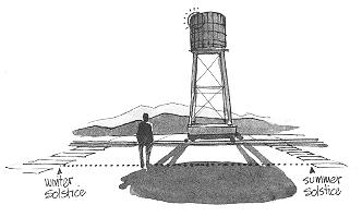 Actually, pinnacles aren’t essential for either calendar or eclipse uses: any cliff profile or
building edge will suffice (you keep one edge of the sun or moon in sight until it crests). Nor is a
circular path essential for eclipse warning: a straight-line path that is approximately north-south
will do (and for calendar-only use, even that requirement can be relaxed).
Actually, pinnacles aren’t essential for either calendar or eclipse uses: any cliff profile or
building edge will suffice (you keep one edge of the sun or moon in sight until it crests). Nor is a
circular path essential for eclipse warning: a straight-line path that is approximately north-south
will do (and for calendar-only use, even that requirement can be relaxed).|
WHEN I HIKED BACK UP the trail out of Canyon de Chelly, a thunderstorm swept over the
area. Fortunately, I’d just passed a small cave in the cliff alongside the trail, so I ran back
down to it. No larger than a park bench, it accommodated me nicely. I looked out on Canyon de
Chelly, seeing the thunderstorm pass over. The view was limited to a small patch of canyon, that
being one problem with alcoves, so I did not see the rainbow until I emerged from the shelter. I wondered what the view would have been like from up in the White House Ruin, what living in such a place would have done to shape your view of the world around you. It certainly provided many opportunities to learn about how the sun moves through the sky with the changing seasons, and how the moon almost mimics the sun’s movements on a far faster time scale. You would have been surrounded by natural measuring instruments, available for forecasting eclipses, thereby improving your chances of stumbling onto one of the simple methods, quite without intending to do so. |